
- Several factors make Northeast snowstorms a challenge to forecast.
- This can include the track of the storm and smaller-scale details.
When a winter storm is threatening the East Coast, you probably hear the word "uncertainty" uttered by meteorologists in the days leading up to the storm.
This is certainly the case with the latest storm, named Winter Storm Orlena by The Weather Channel, which could impact the region early next week. There are signs in the models for a potentially significant snowstorm to start February, but the details on track, timing and strength remain unclear and will determine where and how much snow falls.
While that's probably frustrating, as you want specifics, it's the nature of the setup along the East Coast that can sometimes create difficulties in determining whether you'll see a foot of snow or a slushy inch followed by rain.
Here are some of the factors on why forecasting Northeast winter storms can be a challenge.
1. Major Population at Stake
First and foremost, the population potentially impacted by a winter storm in the Northeast Megalopolis is huge, topping 50 million people.
The amount of attention and scrutiny snowfall forecasts draw in the Northeast is equally as large given the massive impact on schools, businesses and commerce.
With so much at stake, subtle differences in the track and evolution of a storm can be the difference between a high, moderate or low impact event. These impacts not only affect those in the Northeast but can also send ripples of disruption into other parts of the country by disrupting transportation.
Compare that to a similarly difficult forecast situation in a lower-population region of the U.S., where the amount of scrutiny and impacts are far less.
(MORE: Most Challenging Forecasts in the U.S.)

An overlay of city lights across the Northeast Megalopolis, illustrating the dense population.
2. Blame the Atlantic Ocean
The Interstate 95 corridor's close proximity to the Atlantic Ocean can take some of the blame for the difficult snowstorm forecasts in the Northeast.
In coastal storm setups, the Megalopolis can be a battleground between cold air over land and relatively mild air over the Atlantic Ocean.
Depending on which wins out is the difference between a walloping snowstorm near the coast or a messy mix of precipitation.
Another hurdle: intensifying low-pressure systems can create their own cold air through a process called dynamic cooling. This can counteract the warmer Atlantic air, allowing precipitation to remain in the form of snow.

The I-95 corridor can be a battleground between cold air in place over land and relatively warmer air pulled in by the coastal low-pressure system.
3. The Track of the Low and the 40/70 Benchmark
To determine if the cold air or milder Atlantic air wins out, meteorologists examine the track of the developing coastal storm.
The track is critical, and forecast guidance can have trouble honing in on this until within 24 hours of a storm's impact.
Meteorologists often talk about the so-called 40/70 benchmark, which means 40 degrees north latitude and 70 degrees west longitude. In general, when cold air is available over the Northeast, a low tracking through this general point on the globe is in the sweet spot for delivering a thumping snowstorm to at least parts of the Northeast.
If forecast guidance consistently paints this low-pressure track, it typically results in a higher-confidence snowstorm forecast for the Northeast.
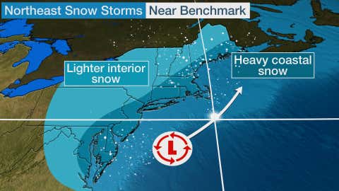
The white dot represents the 40/70 benchmark. A low passing near this point typically results in a significant snowstorm along the East Coast when cold air is available.
4. The Problematic Tracks
Many forecast situations have a lower-confidence track of coastal low-pressure systems that are either west (left) or east (right) of the 40/70 benchmark. What's more, forecast guidance can be erratic in the days leading up to a storm, painting several different low track scenarios.
When this occurs, forecast confidence sometimes drops like a rock.
A track to the west (left) of the benchmark typically ushers in warmer Atlantic air. How far inland that warmer air penetrates can be difficult to diagnose and makes for a frustrating rain/snow line forecast.
Storms can sometimes have a snowfall gradient that ranges from a couple inches to a foot over a distance spanning tens of miles. Where that sets up is the key difference between a high- and low-impact storm in a large metro area such as New York City.
Conversely, a storm that tracks east (right) of the 40/70 benchmark can result in a close call with only a brushing of snowfall on immediate coastal areas.

The white dot represents the 40/70 benchmark. If the low tracks west of that position, then the rain/snow line may set up near or inland from the coast. A track east of that point typically only brings a brushing of snow to the coast.
4. The Finer Details
There are a couple of finer details that sometimes can't be determined until a storm is actually ongoing.
First is the potential for banding snowfall during storms where the coastal low-pressure system is undergoing significant intensification. When these bands of heavy snow exist, they can bring snowfall rates of 1 to 3 inches per hour, locally enhancing snowfall totals in a storm.
One such example is a Feb. 11-12, 2006, winter storm that had an arcing band of heavier snow that set up right over the New York City metro. It dropped 11 inches of snow on the Big Apple in three hours, vaulting the storm total to 26.9 inches at Central Park.
Another detail sometimes not resolved until a storm is underway is what meteorologists call the dreaded dry slot.
As its name implies, the dry slot is a punch of dry air on the eastern flank of a developing coastal storm. This dry air can cut off moisture and reduce the snowfall amounts in some areas compared to what was originally forecast.
The Weather Company’s primary journalistic mission is to report on breaking weather news, the environment and the importance of science to our lives. This story does not necessarily represent the position of our parent company, IBM.
"can" - Google News
January 29, 2021 at 03:40AM
https://ift.tt/2Yp0vZi
Northeast Winter Storms Can Be Difficult to Forecast – Here's Why | The Weather Channel - Articles from The Weather Channel | weather.com - The Weather Channel
"can" - Google News
https://ift.tt/2NE2i6G
https://ift.tt/3d3vX4n
Bagikan Berita Ini


0 Response to "Northeast Winter Storms Can Be Difficult to Forecast – Here's Why | The Weather Channel - Articles from The Weather Channel | weather.com - The Weather Channel"
Post a Comment